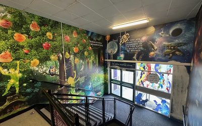
Schools are increasingly rethinking how they view corridors – repositioning them as active learning spaces, rather than sterile walkways.
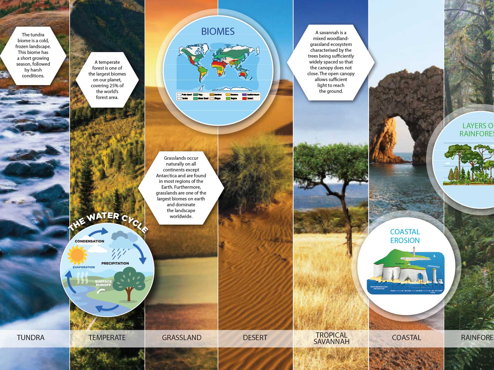
Bespoke world maps can transform bare corridors into a dynamic learning environment that reinforces the geography curriculum. They can help students explore countries, continents and climate zones and make global connections every time they pass by.
By combining bespoke maps, personalised overlays and engaging design features, schools can create corridors that spark curiosity, support classroom learning and strengthen cultural and global awareness.
At Design for Education, we create fully bespoke, high-quality educational wall art, including bespoke world maps and geography wall displays. All our geography wall art is professionally designed, tailored to your school’s curriculum and installed with an industry-leading 5-year guarantee.
Speak to our team today to find out how we can transform your school’s geography corridors
Keep reading to learn more about how bespoke world maps can transform bare corridors into active and engaging learning spaces.
Jump to section:
- How to Turn Geography Corridors into Active Learning Spaces
- The Power of Large-Scale World Maps in Education
- What Makes a Bespoke World Map Different?
- Creative Ways Schools Use World Map Wall Displays
- The Impact of Bespoke World Maps on Student Engagement
- High-Quality Bespoke World Maps and Geography Wall Art by Design for Education
How to Turn Geography Corridors into Active Learning Spaces
Geography corridors offer a useful, but often underutilised, opportunity to extend learning beyond the classroom.
A 2015 research project, ‘Clever Classrooms’, undertaken by the University of Salford, found that:
“Displays outside the classroom on the corridor wall is an efficient way for orientation and avoiding a long institutional-style effect.”
However, corridors can go even further than this – they can become active learning environments that reinforce geography knowledge throughout the school day.
High-traffic areas, like corridors, are ideally suited to reinforce key curriculum concepts, definitions and methods. When students pass by the same displays multiple times a day, this helps to strengthen their understanding of world maps and how countries, continents and oceans exist in relation to each other.
The Power of Large-Scale World Maps in Education
Large-scale world maps installed in geography corridors can be a powerful tool to enhance student understanding and support the teaching of the geography curriculum.
Support the Geography Curriculum
According to the Department for Education, the UK geography curriculum aims to inspire:
“curiosity and fascination about the world and its people that will remain with them for the rest of their lives”.
Across all key stages, understanding and interpreting world maps is an integral part of the geography curriculum.
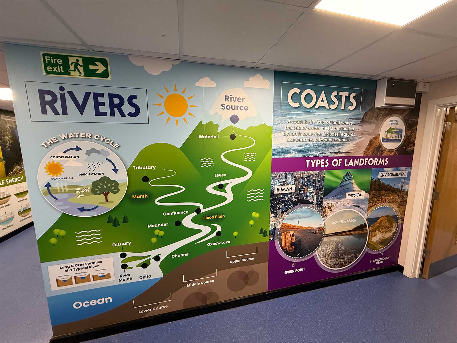
Large-scale displays allow students to visualise countries, continents, oceans and key geographical features repeatedly throughout the school day, reinforcing classroom learning. Maps are central to the geography curriculum because they are the key tool that helps students develop spatial awareness, locational knowledge and visual literacy.
Maps help students:
- Visualise and analyse geographical features
- Understand the relationship between places
- Build locational knowledge and global awareness
- Recognise continents, countries, capital cities, major rivers, mountain ranges and climate zones
- Visualise complex abstract data such as migration patterns, trade networks and population distribution
- Learn a practical life skill that’s needed to effectively navigate the world
- Develop critical thinking skills by looking at the different ways the world is presented
- Make sense of complex global issues
- See where their school fits within the wider context of the world
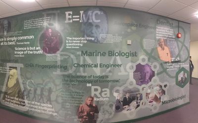
High-quality geography wall art also acts as tangible evidence of curriculum implementation, helping to demonstrate your school’s commitment to the 2025 Education Inspection Framework. Learn more about this in our blog, ‘How School Wall Art Supports Ofsted’s New Inspection Priorities’.
What Makes a Bespoke World Map Different?
At Design for Education, we specialise in designing and installing bespoke world maps and wall displays to enhance student learning and create more engaging learning experiences. So, what sets a bespoke world map apart from an off-the-shelf map display?
Tailored to Your School’s Curriculum
Each map can be customised to reflect the topics and concepts your students are learning. This includes:
- Curriculum-specific features such as climate zones, biomes, trade routes, time zones or migration patterns.
- Highlighting key geographical vocabulary aligned with KS1–KS4 objectives.
- Customising the design to ensure it’s age-appropriate
- Integrating the world map with other subjects, for example, including Viking raiding and trading routes, to align with history teaching
- Adding custom maps that fit with specific areas of focus, such as exploring the effects of climate change
Built to Fit Your Space
Bespoke maps are designed, manufactured and professionally installed to maximise the space you have available. At Design for Education, we can install wall displays on a wide range of surfaces to fit even the most awkward of spaces.
Opting for bespoke wall art means you get:
- Highly readable maps for corridors, stairwells and classrooms
- Custom scales and layouts to suit your school’s architecture
- Maps made from premium and durable materials that are designed to last even in high-traffic areas.
Include Real World Context
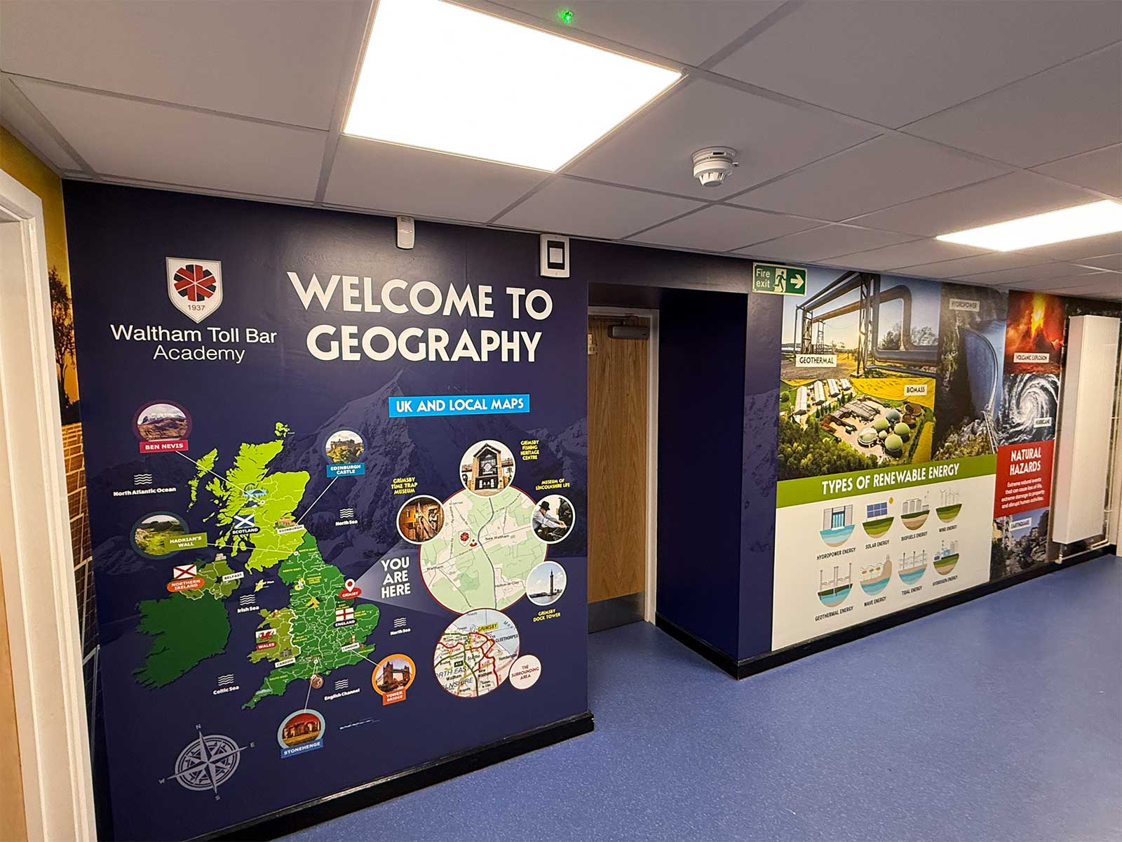
Bespoke maps can be a powerful tool to help students understand how their school and local area fit into the context of the wider world. You can include:
- A UK map with a zoomed-in section focusing on your school, town and key geographical features in the local area
- Clear links between the local area and global locations, helping pupils understand scale and distance
- Markers for school trips, partner schools or places of cultural significance
- Overlays that connect local geography to broader topics, such as climate, population or environment
At East Ward Community Primary School, the Design for Education team opted for a ‘nested’ approach to installing high-quality geography wall art, moving from the local topography of Bury to the national context of the UK. This was key to helping primary school students understand their place in the world.

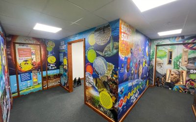
Creative Ways Schools Use World Map Wall Displays
Schools are finding imaginative ways to make world map wall displays both engaging and educational, turning corridors into spaces where students can explore geography through real-world connections.
Here are some examples of how your school can use a world map display to foster global awareness, support the geography curriculum and reinforce classroom learning:
- Highlight your school’s local environment and nearby geographical features, e.g the Peak District
- Pin school trips, partnerships or exchange programmes to show real-world connections
- Map locations from popular TV shows, films or books, to connect learning with popular culture
- Use the map to show biomes and habitats across continents
- Track global modern-day events, such as climate issues or political instability
- Display famous explorers, historical trade routes, or migration paths to support cross-curricular learning
- Link geographical maps to human geographical concepts, such as migration, political borders or population changes
- Highlight local environmental projects or conservation areas near your school
- Showcase endangered species and their natural habitats around the world
- Map volcanoes, earthquakes or tectonic plate boundaries for physical geography lessons
- Add key geographical definitions or facts and figures to further support classroom learning
Working with the Design for Education team means that we will be on hand to design your bespoke world map display, collaborating closely with you to ensure that the final design is fully tailored to your school’s curriculum. It all starts with a free site survey – book yours today!
Bespoke World Map Features
To make the most of your world map display, the Design for Education team uses a range of features to ensure maximum engagement and student learning.
1. Inset Maps
- Small, zoomed-in maps are placed on the same display to show more detail about a specific area (e.g., your school, town, or a local geographical feature).
- Useful for local geography, city maps or detailed environmental features.
2. Callouts
- Text boxes or arrows pointing to specific locations with extra information, fun facts, or statistics.
- Ideal for highlighting historical events, famous explorers, or TV/movie locations.
3. Overlays
- Layers that show additional data on top of the main map, such as biomes, climate zones, population, or migration routes.
4. Pins
- Visual points to indicate school trips, partnerships, places of interest or global events.
5. Thematic Sections
- Areas of the map are dedicated to specific topics, like natural disasters, renewable energy projects, or endangered species.
- Helps break complex global information into digestible chunks.
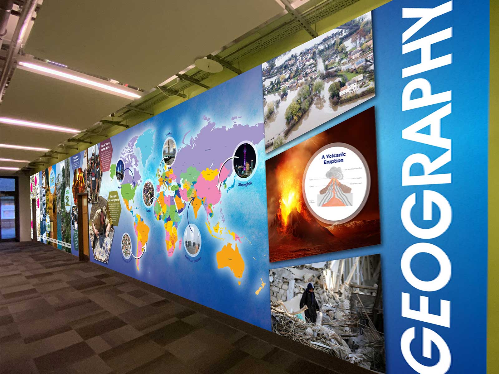
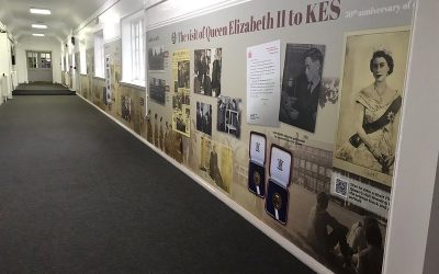
Case Study: Neale Wade Academy Geography Corridor Transformation
The Design for Education designed, manufactured and installed floor-to-ceiling school wall graphics in Neale Wade Academy’s geography corridor. The aim was to create an inspiring, subject-led environment that promotes curiosity and reinforces key geographical themes and global awareness.
The design included:
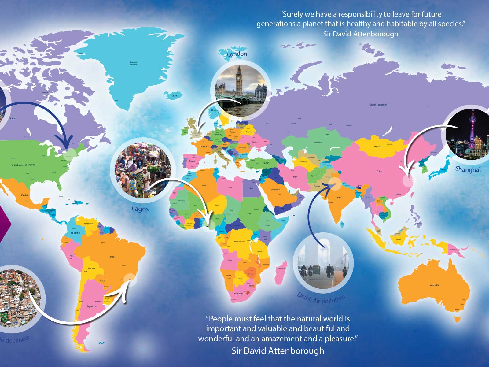
- A large-scale world map with call-outs of notable global locations and inspiring quotes by Sir David Attenborough
- A geography department banner with engaging imagery
- A panel and a smaller world map showing different biomes and key geography concepts, such as the water cycle
- A topographic map of the local area with callouts of local geographical features
The project had a profound impact on how staff and students experience the geography corridor, helping to:
- Reinforce geography terminology and definitions
- Increase student engagement and spark curiosity
- Strengthen school pride and make the geography area a distinct academic zone
- Show the school’s commitment to learning and support of Ofsted objectives
Want to learn more about this geography corridor transformation? Read the full case study for more information.
The Impact of Bespoke World Maps on Student Engagement
Bespoke world maps can transform corridors and have a huge boost on student engagement. They can make learning more visible, engaging and relevant throughout the school day. Repeated exposure to maps reinforces classroom learning, improves retention and helps students understand their place in the world.
Specific impacts include:
- Increased spatial awareness – students can visualise locations, distances, and relationships between places.
- Stronger knowledge retention – repeated exposure to visual information helps memory and understanding.
- Cross-curricular connections – maps encourage links between geography, history, science, and current events.
- Enhanced curiosity and motivation – inset maps, panels and callouts encourage students to explore topics independently and engage more deeply with geography.
By transforming corridors into active learning spaces, schools can create an environment where geography is engaging, memorable, and connected to students’ everyday experiences.
High-Quality Bespoke World Maps and Geography Wall Art by Design for Education
At Design for Education, we design, manufacture and install high-quality bespoke geography wall art and world maps that completely transform your school geography corridor. Our team will work with you to ensure your wall display is fully tailored to your school’s values, curriculum and learning goals. View our Geography case studies to see how we’ve transformed schools across the country.
Every wall display includes our industry-leading 5-year guarantee and professional installation by our expert team.
It all starts with a free site survey – our team will discuss your space, needs and available budget to make sure we get it right. We’ll provide you with a tailored quote estimate based on your requirements, which includes design, manufacturing and professional installation.
More like this…

Create a Lasting Reading Culture Beyond World Book Day With Library Wall Art
With World Book Day fast approaching, schools across the UK are preparing to celebrate books, authors and the joy of reading. But while the costumes and book tokens generate excitement, building a sustainable reading culture requires more than a one-day event....
School Wall Art Trends for 2026
From nurseries to colleges, engaging, colourful and informative wall displays and art installations can transform any space into the perfect setting for learning. As we move into 2026, there are a number of trends due to be big-hitters when it comes to school wall...
How School Wall Art Supports Ofsted’s New Inspection Priorities
Ofsted has recently updated the Education Inspection Framework, moving away from the previous Intent → Implementation → Impact model. Under the 2025 Education Inspection Framework (EIF), schools are evaluated across six clearly defined areas: Curriculum &...
Maximise Educational Impact Through Creative School Wall Murals
Creating School Wall Art That Inspires and Transforms The design of your school’s learning environment plays a crucial role in engagement, motivation, and academic success of your students. Get it right, and you’ll develop a visually stimulating surrounding that...
School Wall Displays: Engaging Students Beyond the Classroom
Unlock the Hidden Power of Your Educational Environment School wall displays are a powerful yet often underutilised tool in education. The power of well-designed, vibrant school wall murals goes far beyond improving the aesthetics of a school. They become an extension...
Designing School Wall Displays to Reflect Core Values and Inspire Students
Creating a Purpose-Led School Environment There are many factors that contribute to a positive learning environment and the success of your students. Often overlooked among them are school wall displays. Indeed, school wall murals can inspire students, ignite...
School Walls as Learning Tools: Engaging Displays for Every Subject
Reimagining School Walls for Dynamic Education In the modern education environment, using school walls as learning tools helps teaching staff to go beyond textbooks and digital screens. Indeed, they are proving to be an integral visual learning tool, with research...
Creating Interactive Learning Through School Walls: Design Tips for Engaging Student Spaces
School walls are for more than just decoration, they can also be powerful teaching tools. By incorporating interactive elements, bold visuals, and engaging layouts, classroom walls can foster hands-on learning and creativity. From subject-themed murals to sensory-friendly designs, the right approach transforms walls into immersive educational experiences. Our guide shows you how to design spaces that captivate students’ attention, encourage participation, and make learning more dynamic every school day.